
|
# |
Content |
Target Function |
Overview |
|---|---|---|---|
|
1 |
Enhancement |
Summary |
Progress gradient colors for ”View Structure Actual Results” in the Summary menu can now be customized. Colors and progress rate thresholds can be changed in the Color Settings dialog. The settings are applied to all structures within the project. |
|
2 |
Enhancement |
Measurement |
”Site” can no longer be selected when creating annotations if no target design (design data) is specified in project. *A tooltip on the button explains why the option is unavailable. |
|
3 |
Enhancement |
Project Settings |
Interpolation can now be enabled by default when uploading point cloud data. When Enable ”Interpolation ON by default” is enabled under Project Settings > Data Integration, Interpolation is automatically turned on for point cloud uploads, helping prevent reprocessing caused by missed settings. 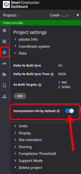
|
|
4 |
Bug fix |
Data layer |
When uploading a DXF file, the “The file is corrupted.” message could appear if a HATCH element was included in a block definition that was not placed in the drawing. This issue has been fixed so that DXF files containing such unused block definitions can now be imported successfully. |
|
5 |
Bug fix |
Data layer |
When importing design data (TP3 files) containing multiple layers, the layer display order could change with each upload. This issue has been fixed so that layers are now displayed in the same order as in the original TP3 file. |
|
6 |
Bug fix |
Data layer |
When uploading survey data, the warning “The center of the LAS header is more than 50 km away from the center of the site.” could appear even when the data was valid. This issue has been fixed so that the incorrect warning is no longer displayed. |
|
7 |
Bug fix |
Data layer |
When uploading large survey data files (approximately 8 GB or larger), the tiling process could stop before completion. This issue has been fixed so that tiling now completes successfully even for large survey data files. |
|
8 |
Bug fix |
Data layer |
During tiling, progress heatmap calculations could take a significant amount of time. This issue has been fixed so that the tiling process now completes within an appropriate amount of time. |
|
9 |
Bug fix |
Data layer |
When registering design data (LandXML), unnecessary lines could appear on the 3D map. This issue has been fixed so that unnecessary lines are no longer displayed. |
|
10 |
Bug fix |
Data layer |
When registering design data (LandXML), some centerline and coordinate point labels could appear at incorrect elevations. This issue has been fixed so that these labels are now displayed at the correct elevations. |
|
11 |
Bug fix |
Data layer |
When design data (LandXML files) contained <Alignments> section, an error could occur during tiling and prevent the data from being registered. This issue has been fixed so that the affected design data can now be registered successfully. |
|
12 |
Bug fix |
Measurement |
Changes to the order of annotations and annotation groups could sometimes not be saved correctly. This issue has been fixed so that annotations and annotation groups are now saved in the specified order. |
|
13 |
Bug fix |
PDF report |
When generating a PDF report, data from a date other than the selected survey data date could be displayed. This issue has been fixed so that the selected data is now displayed correctly. |
|
14 |
Enhancement |
Data layer |
Following the discontinuation of the Everyday Drone (Smart Construction Drone) service, Everyday Drone has been removed from the “+ Add Data Layer” menu. |