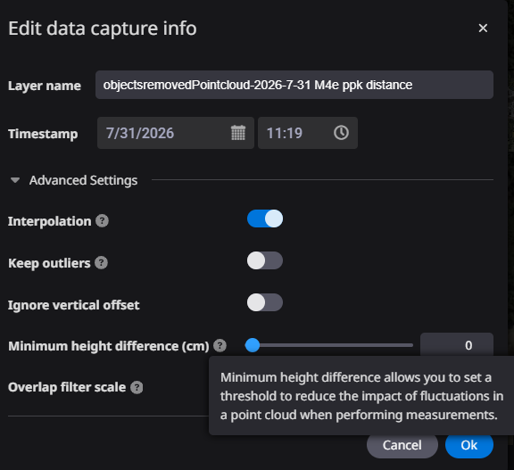
"Minimum height difference" is a per-asset noise tolerance applied at measurement time.
-
How to set it for Edge imports (important)
-
The Edge 2.0 / Everyday Drone import wizards do not expose this field, so a freshly imported
flight always starts at 0. Please use edit feature. -
It is only available for surveys imported as a POINT CLOUD (LAS). If you import the Edge
DSM / DTM (GeoTIFF) instead, the field is not shown at all and the feature cannot be used.
-
Answers to your three questions
(1) Progress Only (project-wide progress and heatmap)
YES, applied. If the current (non-preconstruction) asset has a value greater than 0, that
value is used for both the cut/fill and the progress calculation; if it is 0, the calculation
falls back to the project-level "Completion Threshold" setting. The asset setting takes
priority. Work-area progress behaves the same way, using the current asset's value.(2) Polygon cut/fill, survey vs survey
YES, applied - when both compared assets are Survey assets, and only the value of the asset with the newer timestamp is
used. A Survey vs design comparison is treated as 0.
The same rule applies to Smart volume, work-area cut/fill and the soil calculation CSV export.
* Because the newer asset decides the value, it must be set on every new survey.(3) Elevation history
NO, not applied. Elevation history samples raw heights at points, so flight-to-flight
fluctuation remains visible in the chart by design. -
Recommended setup
-
For Survey-to-survet volume comparisons (polygon / work areas): set e.g. 5 cm on each newly
imported Edge point cloud. -
For project-wide progress and completion: do the same, or set the project-level Completion
Threshold if you want one consistent value (it is used whenever the asset value is 0).